

A Chronicle of Lebanon’s Oil and Gas Pursuits
There is no denying the profound impact oil has had on humankind. In the Middle East, entire nations have risen to great heights, quite literally fueled by newfound petroleum wealth. While the oil and gas history of the Middle East dates back to the beginning of the twentieth century, enthusiasm in the Eastern Mediterranean has resurfaced in the past two decades following the successful exploits of Egypt, Cyprus, Occupied Palestine, and Turkey. Lebanon intends to join the club.
In 2013, a prosperous future of hydrocarbon[1] applications seemed possible in Lebanon when three-dimensional (3D) offshore seismic surveys indicated the presence of natural gas. However, the story had started well before then.

Credits: Research Department of the Foreign Office. (1945). Oilfields & concession areas in the Middle Eastern Countries together with neighbouring oilfields in the U.S.S.R [Map]. British Library.
The Eastern Mediterranean oil and gas industry finds its roots in the 1930s when oil exploration began in Syria. Following successes in neighboring countries, the French Mandate made the decision to legislate the industry. High Commissioner Henry de Jouvenel issued a decision authorizing the excavation, extraction, and exploitation of oil and metal reserves. However, it was not until the 1960s that commercial oil production began. Today, modern technology has shortened this exploration-to-production cycle to roughly 4-10 years, but it often remains an arduous process.
Up until the 1970s, a number of wells were drilled on Lebanese onshore lands, some with depths up to 3,000 meters and most yielding little to no success. As with all oil and gas exploits, Lebanon’s tale of wells is laced with promising indicators and unfortunate disappointments.

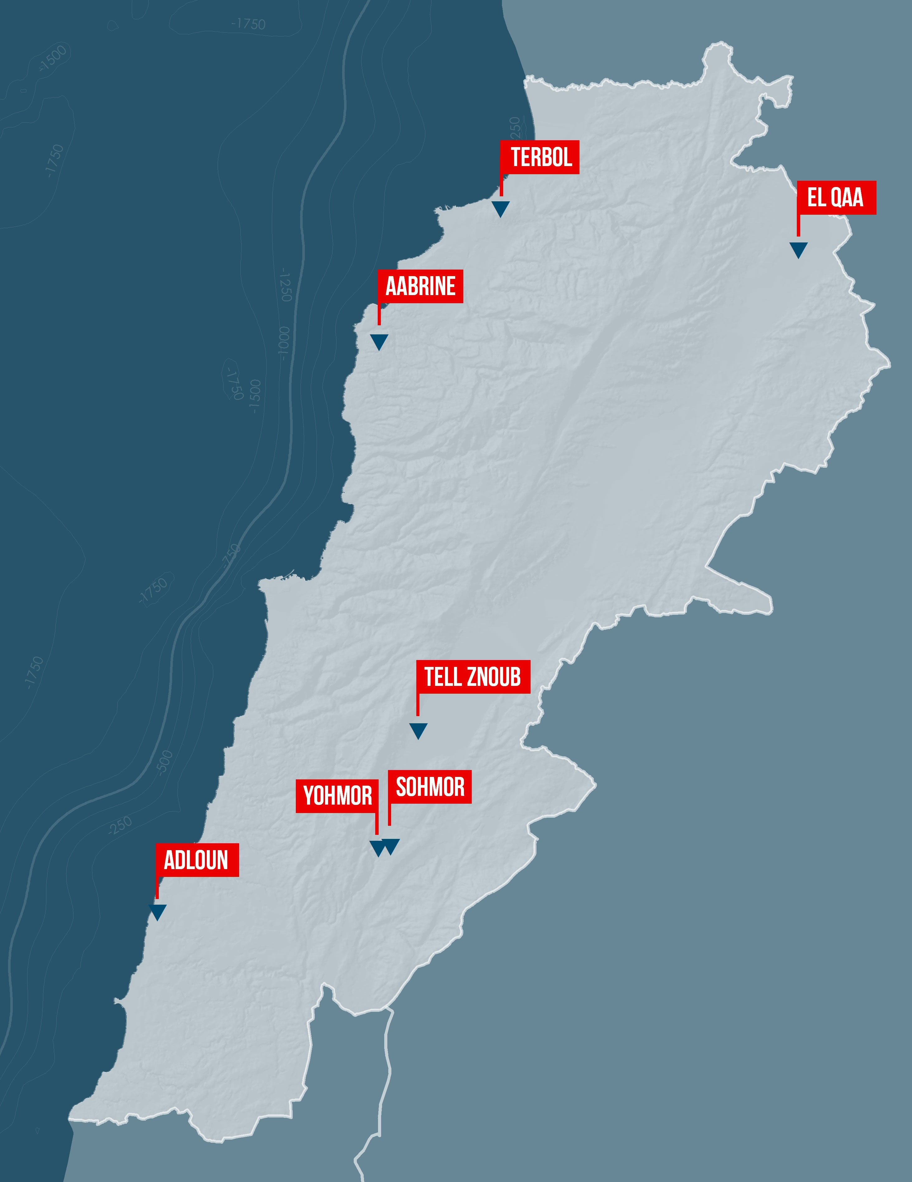
Lebanon’s first well was drilled in 1947 in Terbol (Bekaa region) by the Iraq Petroleum Company. The well reached a depth of almost 2,700 meters below sea level, but didn’t produce any significant signs of hydrocarbons. Another well was drilled in 1953 in Yohmor (south of the Bekaa Valley) by the Petroleum Lebanese Company (PLC). This time, despite no commercial discoveries being made, signs of hydrocarbon presence were recorded, thus giving the PLC the confidence to drill more onshore wells between 1960 and 1963.
Yohmor-1 was followed by Sohmor-1 in an attempt to test the same subsurface structure. Again, there were signs of hydrocarbons, but at a different depth. The hydrocarbon interval, despite being only about 3 kilometers away, was found to be nearly 500 meters thicker than in Yohmor-1. Tell Zenoub-1 was the last of the PLC wells to be drilled, but it had to be abandoned after a water invasion due to its close proximity to the active Yammouneh Fault.[2] El Qaa-1 and Adloun-1 followed the Tell Zenoub-1 well, which were both drilled in the late 1960s. Yet as with earlier wells, there were no signs of hydrocarbons. The last one drilled in this era, Aabrine-1, was excavated by the Shaheen Exploration Company in 1967. It was drilled to a depth of 620 meters before being abandoned due to mechanical difficulties.[3]

Credits: Lebanese Petroleum Association. (n.d.). 7 Wells drilled on Lebanese onshore between 1974 and 1976 [Map].

Credits: Reuters via Nasdaq, energy-pedia, & Total. (n.d.). Location of Blocks 4 & 9 (2nd Round blocks on offer shown in green) [Map].
In the modern oil and gas industry, seismic surveys are seen as one of the first significant steps in understanding the subsurface. The first seismic profiles in Lebanon were acquired between 1959 and 1960 by British geophysical services company Geco Prakla. The survey covered the Hermel region of the northern Bekaa Valley along with the coastal areas of Sidon and Tyre for PLC. Despite the poor quality of the data, it led to the identification of the El Qaa and Adloun structures. The first offshore seismic reading was collected in 1970 by Delta Exploration Company for the Shaheen-Oxoco interests on the continental shelf in offshore Tripoli. Of the 300 kilometers of relatively reliable data gathered, the offshore Ile du Palmier structure was recognized but remains untested.
Following this period of exploration activity in Lebanon, investors had little to no interest in Lebanon’s oil and gas industry due to the low quantities of petroleum estimated and the presence of heavy hydrocarbons. It is important to note that heavy hydrocarbons are more expensive to produce and process. Fading hopes then turned into a complete halt on progress on April 3, 1975, when battles between the Palestinian Liberation Organization and the Kataeb militia spread across Beirut, leading to a demarcation line between the two halves of the city and igniting what we know as the Lebanese Civil War. Under the dark cloud of war, oil exploration activities came to a standstill as the government canceled exploration licenses. However, there are reports of a Bulgarian company conducting exploration activities in 1982.
In the 1990s, as the dust began to settle on the civil war, oil and gas exploration was revived and seismic surveys were restarted in Lebanon’s offshore areas. In 1993, 490 linear kilometers of 2D seismic surveys were completed in an offshore area of northern Lebanon. With the 2D seismic surveys revealing promising results in 2002, the Lebanese government signed contracts with Spectrum, AT Energy, South Hampton, and ECL Group to carry out further offshore seismic surveys. This was followed by a contract with Petroleum Geo-Services, a Norwegian surveyor, in 2006.

Credits: © www.dragonoil.com
Following promising results from a series of recent seismic exploration efforts, the passing of new oil and gas industry legislation commenced in 2010. Parliament passed the Offshore Petroleum Resources Law and a number of application decrees that provided more detailed regulations for the licensing process, which were subsequently adopted by the Council of Ministers. In 2013, the Lebanese Exclusive Economic Zone (EEZ, more commonly known as the “Lebanese Offshore”) was designated, which encompasses around 22,700 square kilometers of maritime area, including 1,200 square kilometers where petroleum activities are prohibited. The EEZ was fully covered by 2D seismic surveys, with 70 percent being covered by 3D surveys. In addition, 6,000 square kilometers (offshore and onshore) had been covered by airborne geophysical data (gravity, magnetic, hyperspectral, radiometry, and electromagnetic surveys). This represented substantial coverage, which was deemed sufficient to kickstart an exploration program.
The focus moved to analyzing and interpreting the gathered exploratory data, and so 10,000 square kilometers of 2D and all available 3D maps were interpreted. This showed well-defined structural and stratigraphic traps [4], which were effectively regarded as prospective sites for natural gas. The Lebanese Petroleum Authority (LPA) led analyses and suggested a sufficient probability that the Lebanese Offshore could be a gas-producing area (as well as oil-producing in smaller relative quantities). This conclusion was corroborated by the findings of additional studies conducted by credible entities who have been involved in gas discoveries in neighboring Mediterranean states.
The stage was then set for Lebanese authorities to launch an initial licensing round, through which international companies would be invited to perform an oil and gas exploration campaign. This campaign would entail the drilling of exploration wells for commercial discovery. Once sufficient discoveries are made, the initial drilling infrastructure can then enable full-on gas production.
The recent steps were an exciting turning point for Lebanon’s gas and oil industry. We will soon see what is to come of these new developments.
-
Any of a class of organic chemical compounds composed only of the elements carbon (C) and hydrogen (H). The carbon atoms join together to form the framework of the compound, and the hydrogen atoms attach to them in many different configurations. Hydrocarbons are the principal constituents of petroleum and natural gas. They serve as fuels and lubricants as well as raw materials for the production of plastics, fibres, rubbers, solvents, explosives, and industrial chemicals.
-
A fault is a fracture or zone of fractures between two blocks of rock. Faults allow the blocks to move relative to each other. This movement may occur rapidly, in the form of an earthquake or may occur slowly, in the form of a creep. Faults may range in length from a few millimeters to thousands of kilometers. Most faults produce repeated displacements over geologic time. During an earthquake, the rock on one side of the fault suddenly slips with respect to the other.
- https://logi-lebanon.org/Timeline, Overview of Lebanese oil exploration here
-
A type of sealed geologic container capable of retaining hydrocarbons, formed by changes in rock type or pinch-outs, unconformities, or sedimentary features such as reefs.
Elias Ghantous
Elias Ghantous specialises in strategy, performance improvement, and digital technology projects within the Energy industry, with a focus on Oil & Gas. He has led a number of impactful and high-profile engagements at Schlumberger Business Consulting, Accenture, and Rolls-Royce Energy, serving national and international energy companies in Europe, the Middle East, and North America. Elias is a McGill University alumnus and Member of the UK’s Energy Institute.


